
Arzheim topographic map
Click on the map to display elevation.
About this map
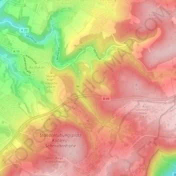
Name: Arzheim topographic map, elevation, terrain.
Location: Arzheim, Koblenz, Rheinland-Pfalz, Deutschland (50.33985 7.62071 50.36169 7.67142)
Average elevation: 820 ft
Minimum elevation: 282 ft
Maximum elevation: 1,099 ft
Other topographic maps
Click on a map to view its topography, its elevation and its terrain.
Koblenz
Deutschland > Rheinland-Pfalz > Koblenz
Koblenz liegt laut Angabe des Bundesamtes für Kartographie und Geodäsie auf 73 m ü. NHN. Das Deutsche Eck liegt bei 64,7 m Höhe. Die höchste vollständig im Stadtgebiet gelegene Erhebung ist mit 382 m der Kühkopf im Stadtwald. Die höchste Stelle des Stadtgebietes mit 385 m befindet sich auf der Grenze…
Average elevation: 787 ft