
Make a donation
Gear up for your next adventure:
As an Amazon Associate, this site earns from qualifying purchases at no extra cost to you.
Rüdeheck topographic map
Click on the map to display elevation.
Make a donation
Gear up for your next adventure:
As an Amazon Associate, this site earns from qualifying purchases at no extra cost to you.
About this map
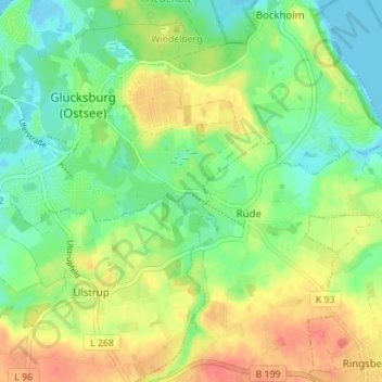
Name: Rüdeheck topographic map, elevation, terrain.
Average elevation: 72 ft
Minimum elevation: -10 ft
Maximum elevation: 164 ft
Make a donation
Gear up for your next adventure:
As an Amazon Associate, this site earns from qualifying purchases at no extra cost to you.
Other topographic maps
Click on a map to view its topography, its elevation and its terrain.
Halbinsel Holnis
Deutschland > Schleswig-Holstein > Schleswig-Flensburg > Glücksburg (Ostsee) > Schausende
Der nördlich und nordöstlich des Kleinen Noors liegende Teil des Naturschutzgebietes wird von eiszeitlichen Moränen gebildet und ist deutlich höher als der südliche Bereich des Naturschutzgebietes gelegen. Die Moränen fallen am Holnis-Kliff im Westen, das am 14. Februar 1978 als Naturdenkmal ausgewiesen…
Average elevation: 3 ft