Geolocate

Langham topographic map

Click on the map to display elevation.

About this map

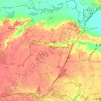
Name: Langham topographic map, elevation, terrain.

Location: Langham, Colchester, Essex, England, United Kingdom (51.92200 0.91446 51.97715 0.97200)

Average elevation: 115 ft

Minimum elevation: 0 ft

Maximum elevation: 174 ft

Gear up for your next adventure:

🧭Pro Hiking Compasses - High-accuracy liquid-filled compasses for topographic orientation
📦Gear Storage Bags - Organize and protect outdoor equipment
📷Action Camera - Capture your outdoor adventures in HD
🪑Portable Camp Table - Compact table for campsite meals
🪶Multi‑Purpose Knife - Useful blade for camp and trail

As an Amazon Associate, this site earns from qualifying purchases at no extra cost to you.