
Rusper topographic map
Click on the map to display elevation.
About this map
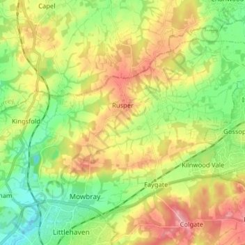
Name: Rusper topographic map, elevation, terrain.
Location: Rusper, Horsham, West Sussex, England, United Kingdom (51.08724 -0.32982 51.14312 -0.20003)
Average elevation: 282 ft
Minimum elevation: 125 ft
Maximum elevation: 489 ft
Other topographic maps
Click on a map to view its topography, its elevation and its terrain.
Smock Alley
United Kingdom > England > West Sussex > Horsham > West Chiltington
Average elevation: 125 ft
Wickhurst Green
United Kingdom > England > West Sussex > Horsham > Wickhurst Green
Average elevation: 148 ft