
Make a donation
Gear up for your next adventure:
As an Amazon Associate, this site earns from qualifying purchases at no extra cost to you.
Parque Azorín topographic map
Click on the map to display elevation.
Make a donation
Gear up for your next adventure:
As an Amazon Associate, this site earns from qualifying purchases at no extra cost to you.
About this map
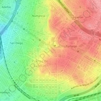
Name: Parque Azorín topographic map, elevation, terrain.
Average elevation: 2,126 ft
Minimum elevation: 1,939 ft
Maximum elevation: 2,280 ft
Make a donation
Gear up for your next adventure:
As an Amazon Associate, this site earns from qualifying purchases at no extra cost to you.
Other topographic maps
Click on a map to view its topography, its elevation and its terrain.
Casino de la Reina
España > Comunidad de Madrid > Área metropolitana de Madrid y Corredor del Henares > Madrid
Average elevation: 2,031 ft
Palacio Real
España > Comunidad de Madrid > Área metropolitana de Madrid y Corredor del Henares > Madrid
Average elevation: 2,070 ft
Valderribas
España > Comunidad de Madrid > Área metropolitana de Madrid y Corredor del Henares > Madrid
Average elevation: 2,188 ft
Villaverde Alto, Casco Histórico de Villaverde
España > Comunidad de Madrid > Área metropolitana de Madrid y Corredor del Henares > Madrid
Average elevation: 1,982 ft
Make a donation
Gear up for your next adventure:
As an Amazon Associate, this site earns from qualifying purchases at no extra cost to you.
Vinateros
España > Comunidad de Madrid > Área metropolitana de Madrid y Corredor del Henares > Madrid
Average elevation: 2,215 ft
Valdezarza
España > Comunidad de Madrid > Área metropolitana de Madrid y Corredor del Henares > Madrid
Average elevation: 2,241 ft
Cuatro Vientos
España > Comunidad de Madrid > Área metropolitana de Madrid y Corredor del Henares > Madrid
Average elevation: 2,238 ft
Las Águilas
España > Comunidad de Madrid > Área metropolitana de Madrid y Corredor del Henares > Madrid
Average elevation: 2,218 ft
Make a donation
Gear up for your next adventure:
As an Amazon Associate, this site earns from qualifying purchases at no extra cost to you.
Peñagrande
España > Comunidad de Madrid > Área metropolitana de Madrid y Corredor del Henares > Madrid
Average elevation: 2,178 ft
Delicias
España > Comunidad de Madrid > Área metropolitana de Madrid y Corredor del Henares > Madrid
Average elevation: 1,975 ft