
Make a donation
Gear up for your next adventure:
As an Amazon Associate, this site earns from qualifying purchases at no extra cost to you.
Neshannock Township topographic map
Click on the map to display elevation.
Make a donation
Gear up for your next adventure:
As an Amazon Associate, this site earns from qualifying purchases at no extra cost to you.
About this map
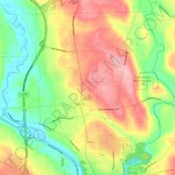
Name: Neshannock Township topographic map, elevation, terrain.
Average elevation: 1,007 ft
Minimum elevation: 781 ft
Maximum elevation: 1,260 ft
Lawrence County trails, hiking, mountain biking, running and outdoor activities
Make a donation
Gear up for your next adventure:
As an Amazon Associate, this site earns from qualifying purchases at no extra cost to you.
Other topographic maps
Click on a map to view its topography, its elevation and its terrain.
Duckrun
United States > Pennsylvania > Lawrence County > Shenango Township
Average elevation: 1,217 ft
East New Castle
United States > Pennsylvania > Lawrence County > Shenango Township
Average elevation: 1,043 ft
Make a donation
Gear up for your next adventure:
As an Amazon Associate, this site earns from qualifying purchases at no extra cost to you.
Plain Grove
United States > Pennsylvania > Lawrence County > Plain Grove Township
Average elevation: 1,181 ft
Fayette
United States > Pennsylvania > Lawrence County > Wilmington Township
Average elevation: 1,056 ft