
Make a donation
Gear up for your next adventure:
As an Amazon Associate, this site earns from qualifying purchases at no extra cost to you.
Cook Island topographic map
Click on the map to display elevation.
Make a donation
Gear up for your next adventure:
As an Amazon Associate, this site earns from qualifying purchases at no extra cost to you.
About this map
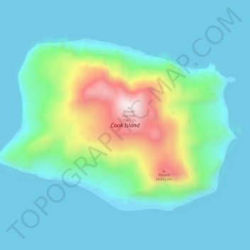
Name: Cook Island topographic map, elevation, terrain.
Average elevation: 633 ft
Minimum elevation: -7 ft
Maximum elevation: 3,622 ft
Make a donation
Gear up for your next adventure:
As an Amazon Associate, this site earns from qualifying purchases at no extra cost to you.
Other topographic maps
Click on a map to view its topography, its elevation and its terrain.
Candlemas Island
South Georgia and the South Sandwich Islands > South Sandwich Islands
Average elevation: 207 ft
Zavodovski Island
South Georgia and the South Sandwich Islands > South Sandwich Islands
The island is one of the most active volcanoes in the South Sandwich Islands. It was reported to be smoking by von Bellingshausen, who observed emissions from the crater and noted a smell of sulfur, and there are frequent reports of steam emission. Reports of eruptions in 1823, 1830 and 1908 may refer to…
Average elevation: 164 ft
South Thule
South Georgia and the South Sandwich Islands > South Sandwich Islands
Average elevation: 85 ft