Geolocate

Molezon topographic map

Click on the map to display elevation.

About this map

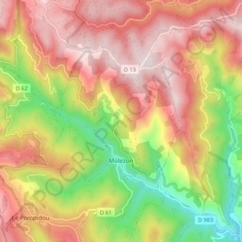
Name: Molezon topographic map, elevation, terrain.

Location: Molezon, Florac, Lozère, Occitania, Metropolitan France, 48110, France (44.19411 3.65360 44.23930 3.72849)

Average elevation: 2,346 ft

Minimum elevation: 1,178 ft

Maximum elevation: 3,297 ft

Other topographic maps

Click on a map to view its topography, its elevation and its terrain.

Sauveplane

France > Occitania > Lozère

Average elevation: 1,519 ft

Les Vanels

France > Occitania > Lozère > Vebron

Average elevation: 2,667 ft

Le Coustat

France > Occitania > Lozère > Nasbinals

Average elevation: 3,944 ft

Cassagnes

France > Occitania > Lozère > Saint-Pierre-des-Tripiers > Cassagnes

Average elevation: 2,362 ft

Biffares

France > Occitania > Lozère > Saint-Alban-sur-Limagnole

Average elevation: 3,225 ft

Lespartis

France > Occitania > Lozère > Peyre en Aubrac > Aumont-Aubrac

Average elevation: 3,435 ft

La Roche

France > Occitania > Lozère > Lajo

Average elevation: 4,006 ft

La Bastide

France > Occitania > Lozère > La Bastide-Puylaurent

Average elevation: 3,556 ft

Gear up for your next adventure:

🪶LED Camping Lantern - Bright lantern for camp lighting
🗺️Topographic Maps - Detailed topo maps for hiking, exploring and outdoor navigation
🏔️Mountain Trail Maps - High‑detail maps for popular peaks
📷Action Camera - Capture your outdoor adventures in HD
🧺Microfiber Travel Towels - Compact and fast-drying towels for trail use

As an Amazon Associate, this site earns from qualifying purchases at no extra cost to you.