Geolocate

Forcalqueiret topographic map

Click on the map to display elevation.

About this map

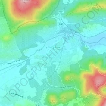
Name: Forcalqueiret topographic map, elevation, terrain.

Location: Forcalqueiret, Brignoles, Var, Provence-Alpes-Côte d'Azur, Metropolitan France, 83136, France (43.31850 6.06148 43.35295 6.11497)

Average elevation: 1,138 ft

Minimum elevation: 925 ft

Maximum elevation: 1,791 ft

Other topographic maps

Click on a map to view its topography, its elevation and its terrain.

Gigaro

France > Provence-Alpes-Côte d'Azur > Var > La Croix-Valmer

Average elevation: 194 ft

Toulon

France > Provence-Alpes-Côte d'Azur > Var > Toulon

Average elevation: 463 ft

Les Martins

France > Provence-Alpes-Côte d'Azur > Var > La Crau

Average elevation: 190 ft

Les Rigaudelles

France > Provence-Alpes-Côte d'Azur > Var > Signes

Average elevation: 1,614 ft

Le Broussan

France > Provence-Alpes-Côte d'Azur > Var > Évenos

Average elevation: 1,204 ft

Les Ferrans

France > Provence-Alpes-Côte d'Azur > Var > Évenos

Average elevation: 1,266 ft

Chibron

France > Provence-Alpes-Côte d'Azur > Var > Signes

Average elevation: 1,667 ft

Le Village

France > Provence-Alpes-Côte d'Azur > Var > Mons

Average elevation: 2,569 ft

Franc

France > Provence-Alpes-Côte d'Azur > Var > Sainte-Maxime

Average elevation: 187 ft

L'Escalet

France > Provence-Alpes-Côte d'Azur > Var > Ramatuelle

Average elevation: 125 ft

Gear up for your next adventure:

❄️Traction Cleats - Prevent slips on icy trails during winter hikes
📱Heavy-Duty Phone Cases - Drop-proof and waterproof protection for outdoor navigation
🩳Quick‑Dry Hiking Shorts - Comfortable and quick‑dry shorts for summer hiking
🎒Outdoor Daypacks - Lightweight backpacks designed for carrying maps and essential gear
🥾Men's Hiking Boots - Durable, waterproof footwear for rugged terrain and steep inclines

As an Amazon Associate, this site earns from qualifying purchases at no extra cost to you.