
Make a donation
Gear up for your next adventure:
As an Amazon Associate, this site earns from qualifying purchases at no extra cost to you.
Colwyn topographic map
Click on the map to display elevation.
Make a donation
Gear up for your next adventure:
As an Amazon Associate, this site earns from qualifying purchases at no extra cost to you.
About this map
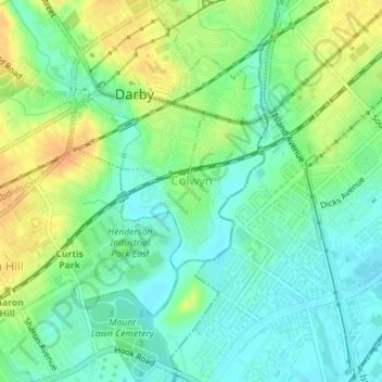
Name: Colwyn topographic map, elevation, terrain.
Location: Colwyn, Delaware County, Pennsylvania, United States (39.90589 -75.26038 39.91715 -75.24678)
Average elevation: 46 ft
Minimum elevation: 0 ft
Maximum elevation: 108 ft
Make a donation
Gear up for your next adventure:
As an Amazon Associate, this site earns from qualifying purchases at no extra cost to you.
Other topographic maps
Click on a map to view its topography, its elevation and its terrain.
Booths Corner
United States > Pennsylvania > Delaware County > Bethel Township
Average elevation: 344 ft
Pendle Hill
United States > Pennsylvania > Delaware County > Nether Providence Township
Average elevation: 200 ft
Chadds Ford Township
United States > Pennsylvania > Delaware County > Chadds Ford Township
Average elevation: 331 ft
Make a donation
Gear up for your next adventure:
As an Amazon Associate, this site earns from qualifying purchases at no extra cost to you.
Havertown
United States > Pennsylvania > Delaware County > Haverford Township
Average elevation: 276 ft
Villanova
United States > Pennsylvania > Delaware County > Radnor Township > Radnor
Average elevation: 390 ft
Newtown Square
United States > Pennsylvania > Delaware County > Newtown Township > Springton Pointe Woods
Average elevation: 387 ft
Make a donation
Gear up for your next adventure:
As an Amazon Associate, this site earns from qualifying purchases at no extra cost to you.
Upper Providence
United States > Pennsylvania > Delaware County > Upper Providence Township
Average elevation: 325 ft
Ithan
United States > Pennsylvania > Delaware County > Radnor Township > Saint Davids
Average elevation: 381 ft
Make a donation
Gear up for your next adventure:
As an Amazon Associate, this site earns from qualifying purchases at no extra cost to you.
Moylan
United States > Pennsylvania > Delaware County > Upper Providence Township
Average elevation: 233 ft
Garrett Hill
United States > Pennsylvania > Delaware County > Radnor Township > Radnor
Average elevation: 384 ft
Make a donation
Gear up for your next adventure:
As an Amazon Associate, this site earns from qualifying purchases at no extra cost to you.
Villanova
United States > Pennsylvania > Delaware County > Radnor Township > Radnor
Average elevation: 390 ft
Havertown
United States > Pennsylvania > Delaware County > Haverford Township
Average elevation: 289 ft
Make a donation
Gear up for your next adventure:
As an Amazon Associate, this site earns from qualifying purchases at no extra cost to you.
Moylan-Rose Valley Station
United States > Pennsylvania > Delaware County > Nether Providence Township
Average elevation: 213 ft
Villanova
United States > Pennsylvania > Delaware County > Radnor Township > Radnor
Average elevation: 390 ft
Chadds Ford
United States > Pennsylvania > Delaware County > Chadds Ford Township
Average elevation: 282 ft
Booths Corner
United States > Pennsylvania > Delaware County > Bethel Township
Average elevation: 344 ft
Make a donation
Gear up for your next adventure:
As an Amazon Associate, this site earns from qualifying purchases at no extra cost to you.
Lapidea
United States > Pennsylvania > Delaware County > Nether Providence Township
Average elevation: 102 ft
Wallingford
United States > Pennsylvania > Delaware County > Nether Providence Township
Average elevation: 135 ft
Make a donation
Gear up for your next adventure:
As an Amazon Associate, this site earns from qualifying purchases at no extra cost to you.
Newtown Square
United States > Pennsylvania > Delaware County > Newtown Township > Springton Pointe Woods
Average elevation: 387 ft
Broomall
United States > Pennsylvania > Delaware County > Marple Township > Broomall
Average elevation: 308 ft
Thornton
United States > Pennsylvania > Delaware County > Thornbury Township
Average elevation: 397 ft
West Ridley Park
United States > Pennsylvania > Delaware County > Ridley Township
Average elevation: 69 ft
Make a donation
Gear up for your next adventure:
As an Amazon Associate, this site earns from qualifying purchases at no extra cost to you.
Penfield
United States > Pennsylvania > Delaware County > Haverford Township
Average elevation: 256 ft
Ardmore Park
United States > Pennsylvania > Delaware County > Haverford Township
Average elevation: 312 ft
Kirklyn
United States > Pennsylvania > Delaware County > Upper Darby > Kirklyn
Average elevation: 230 ft
Make a donation
Gear up for your next adventure:
As an Amazon Associate, this site earns from qualifying purchases at no extra cost to you.
Saint Davids
United States > Pennsylvania > Delaware County > Radnor Township
Average elevation: 400 ft
Ward
United States > Pennsylvania > Delaware County > Concord Township > Ward
Average elevation: 341 ft