
Thank you for supporting this site ❤️
Make a donation
Make a donation
Gear up for your next adventure:
As an Amazon Associate, this site earns from qualifying purchases at no extra cost to you.
Caio Martins topographic map
Click on the map to display elevation.
Thank you for supporting this site ❤️
Make a donation
Make a donation
Gear up for your next adventure:
As an Amazon Associate, this site earns from qualifying purchases at no extra cost to you.
About this map
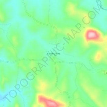
Name: Caio Martins topographic map, elevation, terrain.
Average elevation: 2,526 ft
Minimum elevation: 2,316 ft
Maximum elevation: 2,986 ft
Thank you for supporting this site ❤️
Make a donation
Make a donation
Gear up for your next adventure:
As an Amazon Associate, this site earns from qualifying purchases at no extra cost to you.
Other topographic maps
Click on a map to view its topography, its elevation and its terrain.
Andiroba
Brasil > Minas Gerais > Região Metropolitana de Belo Horizonte > Esmeraldas
Average elevation: 2,766 ft
Melo Viana
Brasil > Minas Gerais > Região Metropolitana de Belo Horizonte > Esmeraldas
Average elevation: 3,009 ft