
Make a donation
Gear up for your next adventure:
As an Amazon Associate, this site earns from qualifying purchases at no extra cost to you.
Bâlea Lake topographic map
Click on the map to display elevation.
Make a donation
Gear up for your next adventure:
As an Amazon Associate, this site earns from qualifying purchases at no extra cost to you.
Bâlea Lake
Bâlea Lake (Romanian: Lacul Bâlea or Bâlea Lac, pronounced [ˈbɨle̯a]; Hungarian: Bilea-tó) is a glacier lake situated at 2,034 m of altitude in the Făgăraș Mountains, in central Romania, in Cârțișoara, Sibiu County. There are two chalets opened all the year round, a meteorological station and a mountain rescue (Salvamont) station. It is accessible by car on the Transfăgărășan road during the summer, and the rest of the year by a cable car from the "Bâlea Cascadă" chalet.
Make a donation
Gear up for your next adventure:
As an Amazon Associate, this site earns from qualifying purchases at no extra cost to you.
About this map
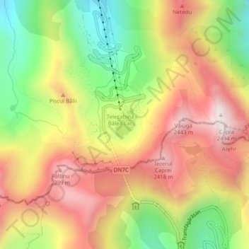
Name: Bâlea Lake topographic map, elevation, terrain.
Location: Bâlea Lake, Cârțișoara, Sibiu, Romania (45.60176 24.61549 45.60483 24.61897)
Average elevation: 6,824 ft
Minimum elevation: 5,453 ft
Maximum elevation: 8,061 ft
Make a donation
Gear up for your next adventure:
As an Amazon Associate, this site earns from qualifying purchases at no extra cost to you.