
Make a donation
Gear up for your next adventure:
As an Amazon Associate, this site earns from qualifying purchases at no extra cost to you.
Bentonville topographic map
Click on the map to display elevation.
Make a donation
Gear up for your next adventure:
As an Amazon Associate, this site earns from qualifying purchases at no extra cost to you.
Bentonville
It lies along County Road 700N northwest of the city of Connersville, the county seat of Fayette County. Its elevation is 1,060 feet (323 m), and it is located at 39°44′43″N 85°11′39″W / 39.74528°N 85.19417°W / 39.74528; -85.19417 (39.7453242, -85.1941317).
Make a donation
Gear up for your next adventure:
As an Amazon Associate, this site earns from qualifying purchases at no extra cost to you.
About this map
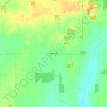
Name: Bentonville topographic map, elevation, terrain.
Location: Bentonville, Fayette County, Indiana, 47322, United States (39.72515 -85.26388 39.76515 -85.22388)
Average elevation: 1,060 ft
Minimum elevation: 1,004 ft
Maximum elevation: 1,122 ft
Fayette County trails, hiking, mountain biking, running and outdoor activities
Make a donation
Gear up for your next adventure:
As an Amazon Associate, this site earns from qualifying purchases at no extra cost to you.