Geolocate

Walcott topographic map

Click on the map to display elevation.

About this map

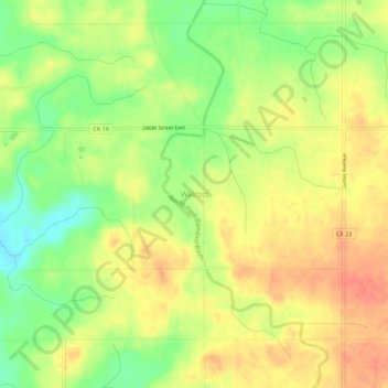
Name: Walcott topographic map, elevation, terrain.

Location: Walcott, Rice County, Minnesota, United States (44.21330 -93.20355 44.25330 -93.16355)

Average elevation: 1,184 ft

Minimum elevation: 1,086 ft

Maximum elevation: 1,260 ft

Rice County trails, hiking, mountain biking, running and outdoor activities

Other topographic maps

Click on a map to view its topography, its elevation and its terrain.

Morristown

United States > Minnesota > Rice County

Average elevation: 1,037 ft

Faribault

United States > Minnesota > Rice County

Average elevation: 1,066 ft

Gear up for your next adventure:

📦Dry Bags Set - Waterproof storage for electronics and clothes
🧭Hiking Compass - Precision compass for reliable navigation in the wilderness
🏕️Family Camping Gear - Essentials for group camping trips
💧Water Filtration Bottles - Safely drink from streams and lakes while exploring
🧢Outdoor Hiking Hat - Sun protection hat for outdoor explorers

As an Amazon Associate, this site earns from qualifying purchases at no extra cost to you.