
Make a donation
Gear up for your next adventure:
As an Amazon Associate, this site earns from qualifying purchases at no extra cost to you.
Góis topographic map
Click on the map to display elevation.
Make a donation
Gear up for your next adventure:
As an Amazon Associate, this site earns from qualifying purchases at no extra cost to you.
Góis
The mountains of the Penedo de Góis, which are part of the Serra da Lousã (Lousã Mountains), at a height of 1,043 metres (3,422 ft), have an accentuated orography with many climatic differences; the Lousã represents the end of the southwest-central cordillera, with elevations between 800 metres (2,600 ft) and 1,200 metres (3,900 ft) above sea level, with accentuated slopes (resulting in steep cliffs that are mostly inaccessible) on the northern flanks and gentle in the south influenced by Atlantic and Mediterranean weather systems.
Make a donation
Gear up for your next adventure:
As an Amazon Associate, this site earns from qualifying purchases at no extra cost to you.
About this map
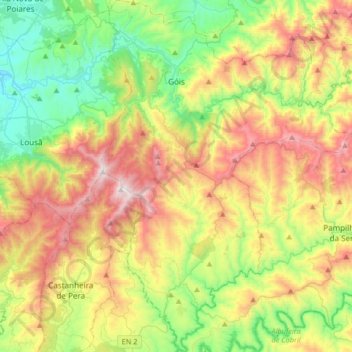
Name: Góis topographic map, elevation, terrain.
Location: Góis, Coimbra, Portugal (39.96023 -8.18039 40.21286 -7.94867)
Average elevation: 1,690 ft
Minimum elevation: 223 ft
Maximum elevation: 3,934 ft
Make a donation
Gear up for your next adventure:
As an Amazon Associate, this site earns from qualifying purchases at no extra cost to you.
Other topographic maps
Click on a map to view its topography, its elevation and its terrain.