Geolocate

Mchinga topographic map

Click on the map to display elevation.

About this map

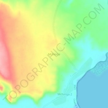
Name: Mchinga topographic map, elevation, terrain.

Location: Mchinga, Lindi, Lindi Region, Coastal Zone, Tanzania (-9.73659 39.68861 -9.69659 39.72861)

Average elevation: 171 ft

Minimum elevation: -7 ft

Maximum elevation: 410 ft

Other topographic maps

Click on a map to view its topography, its elevation and its terrain.

Ruangwa

Tanzania > Lindi Region

Average elevation: 1,198 ft

Kilwa

Tanzania > Lindi Region

Average elevation: 587 ft

Kilwa Kisiwani

Tanzania > Lindi Region > Kilwa Kisiwani

Average elevation: 20 ft

Ruangwa

Tanzania > Lindi Region

Average elevation: 1,198 ft

Kilwa Kisiwani

Tanzania > Lindi Region > Kilwa Kisiwani

Average elevation: 20 ft

Gear up for your next adventure:

🪵Folding Camp Saw - Compact saw for wood and campsite work
🎒Hydration Pack - Hands‑free water reservoir for long hikes
🔊Portable Camp Speaker - Music and alerts at camp
⛑️Personal Locator Beacon - Safety beacon for emergencies
🧦Hiking Socks - Comfortable socks to prevent blisters on long hikes

As an Amazon Associate, this site earns from qualifying purchases at no extra cost to you.