
Make a donation
Gear up for your next adventure:
As an Amazon Associate, this site earns from qualifying purchases at no extra cost to you.
Lohmen topographic map
Click on the map to display elevation.
Make a donation
Gear up for your next adventure:
As an Amazon Associate, this site earns from qualifying purchases at no extra cost to you.
About this map
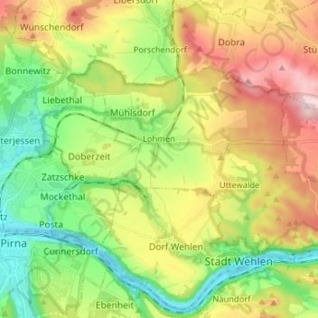
Name: Lohmen topographic map, elevation, terrain.
Average elevation: 741 ft
Minimum elevation: 358 ft
Maximum elevation: 1,302 ft
Make a donation
Gear up for your next adventure:
As an Amazon Associate, this site earns from qualifying purchases at no extra cost to you.
Other topographic maps
Click on a map to view its topography, its elevation and its terrain.
Topograph
Germany > Saxony > Sächsische Schweiz-Osterzgebirge > Rosenthal-Bielatal
Average elevation: 1,263 ft
Kleiner Sandberg
Germany > Saxony > Sächsische Schweiz-Osterzgebirge > Lohmen
Average elevation: 873 ft
Malter
Germany > Saxony > Sächsische Schweiz-Osterzgebirge > Dippoldiswalde
Average elevation: 1,217 ft
Make a donation
Gear up for your next adventure:
As an Amazon Associate, this site earns from qualifying purchases at no extra cost to you.
Siamesische Zwillinge, Dick
Germany > Saxony > Sächsische Schweiz-Osterzgebirge > Bad Schandau
Average elevation: 1,201 ft