Geolocate

Longview topographic map

Click on the map to display elevation.

About this map

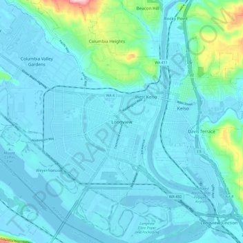
Name: Longview topographic map, elevation, terrain.

Location: Longview, Cowlitz County, Washington, 98626, United States (46.09770 -122.97446 46.17770 -122.89446)

Average elevation: 85 ft

Minimum elevation: -16 ft

Maximum elevation: 738 ft

Cowlitz County trails, hiking, mountain biking, running and outdoor activities

Gear up for your next adventure:

🧭Outdoor Navigation Book - Learn advanced navigation skills
👟Trail Running Shoes - Lightweight shoes for trail runners
📶Vehicle Signal Boosters - Improve reception in rural areas while driving to trailheads
💧Water Filtration Bottles - Safely drink from streams and lakes while exploring
🪶Camping Sleeping Pad - Comfortable sleeping pad for backpacking

As an Amazon Associate, this site earns from qualifying purchases at no extra cost to you.