Geolocate

Veer topographic map

Click on the map to display elevation.

About this map

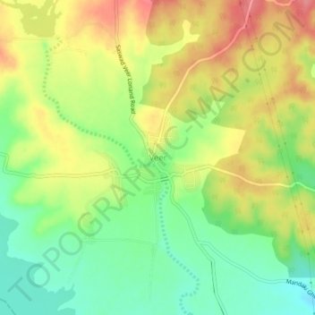
Name: Veer topographic map, elevation, terrain.

Location: Veer, Purandhar, Pune District, Maharashtra, 412311, India (18.13340 74.06827 18.17340 74.10827)

Average elevation: 1,972 ft

Minimum elevation: 1,844 ft

Maximum elevation: 2,110 ft

Other topographic maps

Click on a map to view its topography, its elevation and its terrain.

Purandar Fort

India > Maharashtra > Purandhar > Narayanpur

Average elevation: 3,369 ft

Purandar Fort

India > Maharashtra > Purandhar > Narayanpur

Average elevation: 3,369 ft

Gear up for your next adventure:

❄️Traction Cleats - Prevent slips on icy trails during winter hikes
🎒Waterproof Dry Bags - Keep your electronics and maps dry inside your pack
🥄Camping Utensil Set - Lightweight utensils for outdoor meals
🚑Emergency Bivvies - Heat-reflective sleeping bags for survival situations
🪶Survival Guide Book - Expert advice for emergency preparedness

As an Amazon Associate, this site earns from qualifying purchases at no extra cost to you.