
Thank you for supporting this site ❤️
Make a donation
Make a donation
Gear up for your next adventure:
As an Amazon Associate, this site earns from qualifying purchases at no extra cost to you.
Marganell topographic map
Click on the map to display elevation.
Thank you for supporting this site ❤️
Make a donation
Make a donation
Gear up for your next adventure:
As an Amazon Associate, this site earns from qualifying purchases at no extra cost to you.
About this map
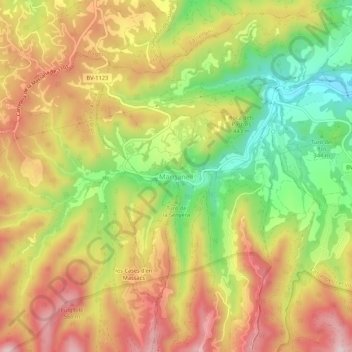
Name: Marganell topographic map, elevation, terrain.
Location: Marganell, Bages, Barcelona, Cataluña, 08253, España (41.62067 1.77002 41.66067 1.81002)
Average elevation: 1,332 ft
Minimum elevation: 741 ft
Maximum elevation: 1,867 ft
Thank you for supporting this site ❤️
Make a donation
Make a donation
Gear up for your next adventure:
As an Amazon Associate, this site earns from qualifying purchases at no extra cost to you.