
Thank you for supporting this site ❤️
Make a donation
Make a donation
Gear up for your next adventure:
As an Amazon Associate, this site earns from qualifying purchases at no extra cost to you.
Ndola topographic map
Click on the map to display elevation.
Thank you for supporting this site ❤️
Make a donation
Make a donation
Gear up for your next adventure:
As an Amazon Associate, this site earns from qualifying purchases at no extra cost to you.
About this map
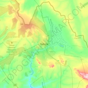
Name: Ndola topographic map, elevation, terrain.
Location: Ndola, Ndola District, Copperbelt Province, Zambia (-13.12931 28.47659 -12.80931 28.79659)
Average elevation: 4,222 ft
Minimum elevation: 3,927 ft
Maximum elevation: 4,872 ft
Thank you for supporting this site ❤️
Make a donation
Make a donation
Gear up for your next adventure:
As an Amazon Associate, this site earns from qualifying purchases at no extra cost to you.