Geolocate

Kokomo topographic map

Click on the map to display elevation.

About this map

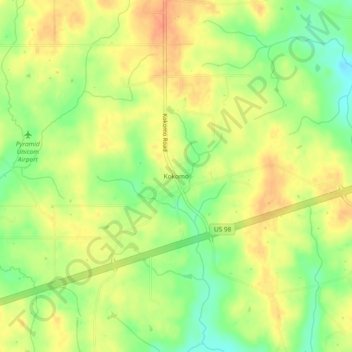
Name: Kokomo topographic map, elevation, terrain.

Location: Kokomo, Marion County, Mississippi, 39643, United States (31.17740 -90.02286 31.21740 -89.98286)

Average elevation: 358 ft

Minimum elevation: 279 ft

Maximum elevation: 417 ft

Marion County trails, hiking, mountain biking, running and outdoor activities

Other topographic maps

Click on a map to view its topography, its elevation and its terrain.

Columbia

United States > Mississippi > Marion County

Average elevation: 171 ft

Gear up for your next adventure:

🔭Telescopic Hiking Pole - Adjustable pole for hiking stability
📻Weather Alert Radios - Stay informed of storm risks while off-the-grid
Camping Coffee Makers - Enjoy premium coffee at the summit or campsite
🪶Thermal Camp Blanket - Extra warmth for cold nights
🔭Compact Binoculars - HD vision for scouting terrain and identifying distant landmarks

As an Amazon Associate, this site earns from qualifying purchases at no extra cost to you.