
Make a donation
Gear up for your next adventure:
As an Amazon Associate, this site earns from qualifying purchases at no extra cost to you.
Piesberg topographic map
Click on the map to display elevation.
Make a donation
Gear up for your next adventure:
As an Amazon Associate, this site earns from qualifying purchases at no extra cost to you.
About this map
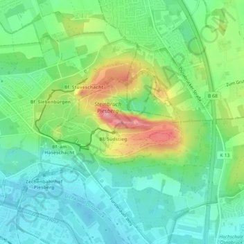
Name: Piesberg topographic map, elevation, terrain.
Location: Piesberg, Osnabrück, Niedersachsen, 49090, Deutschland (52.31772 8.01922 52.31782 8.01932)
Average elevation: 315 ft
Minimum elevation: 180 ft
Maximum elevation: 597 ft
Make a donation
Gear up for your next adventure:
As an Amazon Associate, this site earns from qualifying purchases at no extra cost to you.
Other topographic maps
Click on a map to view its topography, its elevation and its terrain.
Kalkhügel
Deutschland > Niedersachsen > Osnabrück
Kalkhügel ist ein Stadtteil von Osnabrück mit 6.389 Einwohnern (12/2022), die sich auf 3,02 km² Fläche verteilen. Benannt ist der Stadtteil nach einer 94 Meter hohen Anhöhe, die Teil des Osnabrücker Hügellands ist.
Average elevation: 282 ft
Make a donation
Gear up for your next adventure:
As an Amazon Associate, this site earns from qualifying purchases at no extra cost to you.
Make a donation
Gear up for your next adventure:
As an Amazon Associate, this site earns from qualifying purchases at no extra cost to you.
Westerberg
Deutschland > Niedersachsen > Osnabrück
Der Stadtteil Westerberg ist nach einer rund 100 Meter ü. NHN hohen Anhöhe westlich der Osnabrücker Innenstadt benannt. Die Anhöhe selbst ist begrünt und dient der Bevölkerung als Naherholungsgebiet. Außergewöhnlich für eine Großstadt ist, dass „mitten in der Stadt“ noch ein…
Average elevation: 240 ft
Make a donation
Gear up for your next adventure:
As an Amazon Associate, this site earns from qualifying purchases at no extra cost to you.