
Hewitt topographic map
Click on the map to display elevation.
About this map
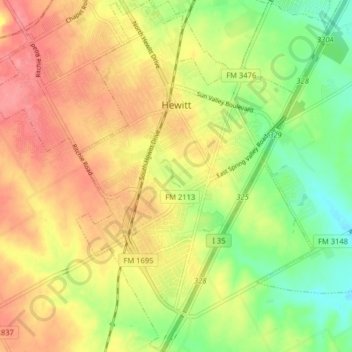
Name: Hewitt topographic map, elevation, terrain.
Location: Hewitt, McLennan County, Texas, 76643, United States (31.41429 -97.21849 31.48264 -97.16902)
Average elevation: 623 ft
Minimum elevation: 492 ft
Maximum elevation: 738 ft
McLennan County trails, hiking, mountain biking, running and outdoor activities
Other topographic maps
Click on a map to view its topography, its elevation and its terrain.
Northcrest
United States > Texas > McLennan County > Lacy-Lakeview > Northcrest
Average elevation: 489 ft