Geolocate

Miengo topographic map

Click on the map to display elevation.

About this map

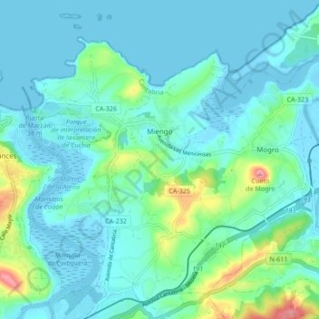
Name: Miengo topographic map, elevation, terrain.

Location: Miengo, Santander, Cantabria, Spain (43.39713 -4.03639 43.45317 -3.95199)

Average elevation: 89 ft

Minimum elevation: -23 ft

Maximum elevation: 531 ft

Gear up for your next adventure:

🧥Men's Rain Shells - Premium waterproof and breathable jackets for mountain weather
🪵Folding Camp Saw - Compact saw for wood and campsite work
📶Satellite Messenger - Communication device off‑grid
🪶Paracord Bracelet - Survival bracelet with built‑in tools
🦶Carbon Trekking Poles - Reduce knee impact on steep descents with ultra-light poles

As an Amazon Associate, this site earns from qualifying purchases at no extra cost to you.