Geolocate

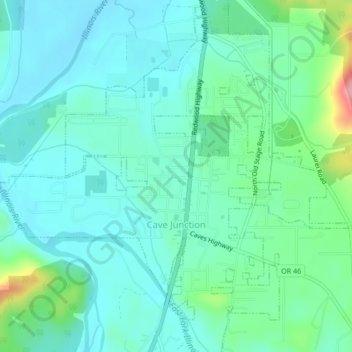
Cave Junction topographic map

Click on the map to display elevation.

Cave Junction

Cave Junction is located on U.S. Route 199 at its junction with Oregon Route 46. It is about 30 miles or 48 kilometres southwest of Grants Pass, Oregon and 53 miles or 85 kilometres northeast of Crescent City, California. The city lies in the Illinois Valley, on the northwest slope of the Siskiyou Range, at an elevation of about 480 metres (1,570 ft) above MSL. According to the United States Census Bureau, the city has a total area of 1.82 square miles (4.71 km2), of which, 1.81 square miles (4.69 km2) is land and 0.01 square miles (0.03 km2) is water.

Wikipedia (CC-BY-SA 3.0)

About this map

Name: Cave Junction topographic map, elevation, terrain.

Location: Cave Junction, Josephine County, Oregon, United States (42.15112 -123.66927 42.18391 -123.62706)

Average elevation: 1,348 ft

Minimum elevation: 1,240 ft

Maximum elevation: 1,804 ft

Josephine County trails, hiking, mountain biking, running and outdoor activities

Other topographic maps

Click on a map to view its topography, its elevation and its terrain.

Wolf Creek

United States > Oregon > Josephine County

Average elevation: 1,713 ft

Hugo

United States > Oregon > Josephine County

Average elevation: 1,568 ft

Merlin

United States > Oregon > Josephine County

Average elevation: 1,010 ft

Galice

United States > Oregon > Josephine County

Average elevation: 1,319 ft

Williams

United States > Oregon > Josephine County

Average elevation: 1,588 ft

Golden

United States > Oregon > Josephine County

Average elevation: 2,185 ft

Three Pines

United States > Oregon > Josephine County

Average elevation: 1,220 ft

Murphy

United States > Oregon > Josephine County

Average elevation: 1,289 ft

Lake Selmac

United States > Oregon > Josephine County

Average elevation: 1,457 ft

Wonder

United States > Oregon > Josephine County

Average elevation: 1,467 ft

Gear up for your next adventure:

👟Men's Trail Runners - Lightweight footwear for fast-paced exploration and light hiking
🔭Stargazing Telescopes - Perfect for camping in low-light pollution areas shown on maps
🥾Women's Hiking Boots - Top-rated trail boots with ankle support and superior grip
🗺️NatGeo Topo Maps - High-quality waterproof printed topographic maps of US Parks
🥄Camping Utensil Set - Lightweight utensils for outdoor meals

As an Amazon Associate, this site earns from qualifying purchases at no extra cost to you.