
Make a donation
Gear up for your next adventure:
As an Amazon Associate, this site earns from qualifying purchases at no extra cost to you.
Higuerote topographic map
Click on the map to display elevation.
Make a donation
Gear up for your next adventure:
As an Amazon Associate, this site earns from qualifying purchases at no extra cost to you.
About this map
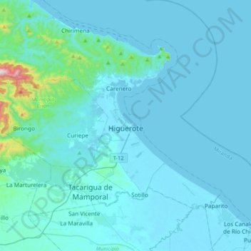
Name: Higuerote topographic map, elevation, terrain.
Average elevation: 141 ft
Minimum elevation: -3 ft
Maximum elevation: 2,500 ft
Make a donation
Gear up for your next adventure:
As an Amazon Associate, this site earns from qualifying purchases at no extra cost to you.
Other topographic maps
Click on a map to view its topography, its elevation and its terrain.
Río Capaya
Venezuela > Estado Miranda > Municipio Brión > Parroquia Higuerote > Boca Vieja
Average elevation: 10 ft
Plaza de Maturín
Venezuela > Estado Miranda > Municipio Brión > Tacarigua de Mamporal
Average elevation: 121 ft
Make a donation
Gear up for your next adventure:
As an Amazon Associate, this site earns from qualifying purchases at no extra cost to you.