
Make a donation
Gear up for your next adventure:
As an Amazon Associate, this site earns from qualifying purchases at no extra cost to you.
Pombal topographic map
Click on the map to display elevation.
Make a donation
Gear up for your next adventure:
As an Amazon Associate, this site earns from qualifying purchases at no extra cost to you.
Pombal
Ambas emitem a partir da Serra de Sicó, no município, a cerca de 400m de altitude, tendo a CardalFM uma potência aparente radiada (PAR) de 2 kW, de acordo com a ANACOM, e a 97FM tendo uma potência de 1 kW. As condições favoráveis de propagação de sinal permitem que a CardalFM, a rádio com maior PAR, se faça ouvir com qualidade na totalidade das regiões de Leiria e de Coimbra.
Make a donation
Gear up for your next adventure:
As an Amazon Associate, this site earns from qualifying purchases at no extra cost to you.
About this map
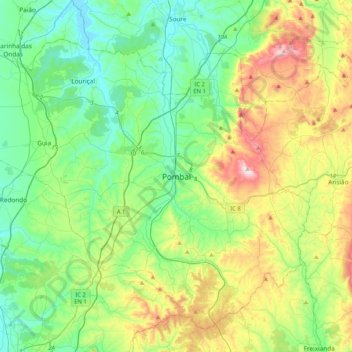
Name: Pombal topographic map, elevation, terrain.
Location: Pombal, Leiria, 3100-494, Portugal (39.75619 -8.78792 40.07619 -8.46792)
Average elevation: 528 ft
Minimum elevation: -3 ft
Maximum elevation: 1,821 ft
Make a donation
Gear up for your next adventure:
As an Amazon Associate, this site earns from qualifying purchases at no extra cost to you.
Other topographic maps
Click on a map to view its topography, its elevation and its terrain.
Make a donation
Gear up for your next adventure:
As an Amazon Associate, this site earns from qualifying purchases at no extra cost to you.
Make a donation
Gear up for your next adventure:
As an Amazon Associate, this site earns from qualifying purchases at no extra cost to you.
Make a donation
Gear up for your next adventure:
As an Amazon Associate, this site earns from qualifying purchases at no extra cost to you.
Make a donation
Gear up for your next adventure:
As an Amazon Associate, this site earns from qualifying purchases at no extra cost to you.