
Thank you for supporting this site ❤️
Make a donation
Make a donation
Gear up for your next adventure:
As an Amazon Associate, this site earns from qualifying purchases at no extra cost to you.
Cornaley topographic map
Click on the map to display elevation.
Thank you for supporting this site ❤️
Make a donation
Make a donation
Gear up for your next adventure:
As an Amazon Associate, this site earns from qualifying purchases at no extra cost to you.
About this map
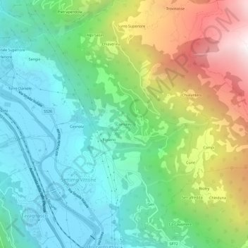
Name: Cornaley topographic map, elevation, terrain.
Location: Cornaley, Settimo Vittone, Turin, Piémont, 10013, Italie (45.53870 7.82268 45.57870 7.86268)
Average elevation: 2,543 ft
Minimum elevation: 843 ft
Maximum elevation: 6,132 ft
Thank you for supporting this site ❤️
Make a donation
Make a donation
Gear up for your next adventure:
As an Amazon Associate, this site earns from qualifying purchases at no extra cost to you.