
Thank you for supporting this site ❤️
Make a donation
Make a donation
Gear up for your next adventure:
As an Amazon Associate, this site earns from qualifying purchases at no extra cost to you.
Alpette topographic map
Click on the map to display elevation.
Thank you for supporting this site ❤️
Make a donation
Make a donation
Gear up for your next adventure:
As an Amazon Associate, this site earns from qualifying purchases at no extra cost to you.
Alpette
Der Ort liegt auf einer Höhe von 957 m über dem Meeresspiegel. Das Gemeindegebiet umfasst eine Fläche von 5 km².
Thank you for supporting this site ❤️
Make a donation
Make a donation
Gear up for your next adventure:
As an Amazon Associate, this site earns from qualifying purchases at no extra cost to you.
About this map
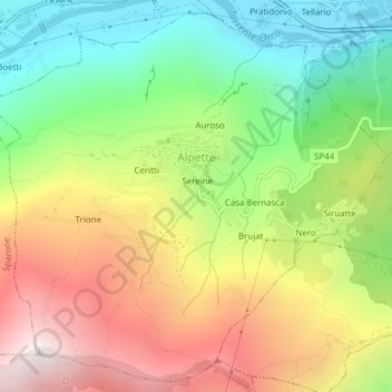
Name: Alpette topographic map, elevation, terrain.
Location: Alpette, Torino, Piemont, Italien (45.39347 7.55939 45.41889 7.59772)
Average elevation: 3,215 ft
Minimum elevation: 1,453 ft
Maximum elevation: 5,390 ft
Thank you for supporting this site ❤️
Make a donation
Make a donation
Gear up for your next adventure:
As an Amazon Associate, this site earns from qualifying purchases at no extra cost to you.