
Thank you for supporting this site ❤️
Make a donation
Make a donation
Gear up for your next adventure:
As an Amazon Associate, this site earns from qualifying purchases at no extra cost to you.
Haute-Vienne topographic map
Click on the map to display elevation.
Thank you for supporting this site ❤️
Make a donation
Make a donation
Gear up for your next adventure:
As an Amazon Associate, this site earns from qualifying purchases at no extra cost to you.
About this map
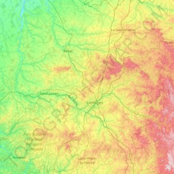
Name: Haute-Vienne topographic map, elevation, terrain.
Location: Haute-Vienne, Nouvelle-Aquitaine, Metropolitan France, France (45.43659 0.62934 46.40145 1.91041)
Average elevation: 1,083 ft
Minimum elevation: 249 ft
Maximum elevation: 3,002 ft
Thank you for supporting this site ❤️
Make a donation
Make a donation
Gear up for your next adventure:
As an Amazon Associate, this site earns from qualifying purchases at no extra cost to you.