Geolocate

Decatur topographic map

Click on the map to display elevation.

About this map

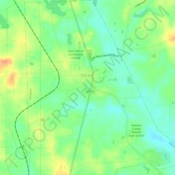
Name: Decatur topographic map, elevation, terrain.

Location: Decatur, Newton County, Mississippi, 39327, United States (32.41391 -89.12720 32.45787 -89.07725)

Average elevation: 410 ft

Minimum elevation: 341 ft

Maximum elevation: 518 ft

Newton County trails, hiking, mountain biking, running and outdoor activities

Other topographic maps

Click on a map to view its topography, its elevation and its terrain.

Little Rock

United States > Mississippi > Newton County

Average elevation: 476 ft

Gear up for your next adventure:

📡Handheld GPS Device - Reliable handheld GPS for outdoor navigation
🔦Compact Flashlight - Reliable flashlight for emergencies
🪶Compact Camp Shovel - Folding shovel for campsite tasks
🎁Geography Themed Gifts - Unique gift ideas for map lovers and geography enthusiasts
📶Satellite Messenger - Communication device off‑grid

As an Amazon Associate, this site earns from qualifying purchases at no extra cost to you.