
Hulett topographic map
Click on the map to display elevation.
About this map
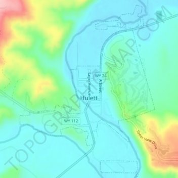
Name: Hulett topographic map, elevation, terrain.
Location: Hulett, Crook County, Wyoming, 18272, United States (44.67138 -104.61640 44.69688 -104.58756)
Average elevation: 3,862 ft
Minimum elevation: 3,737 ft
Maximum elevation: 4,252 ft
Crook County trails, hiking, mountain biking, running and outdoor activities