
Thank you for supporting this site ❤️
Make a donation
Make a donation
Gear up for your next adventure:
As an Amazon Associate, this site earns from qualifying purchases at no extra cost to you.
Waldviertel topographic map
Click on the map to display elevation.
Thank you for supporting this site ❤️
Make a donation
Make a donation
Gear up for your next adventure:
As an Amazon Associate, this site earns from qualifying purchases at no extra cost to you.
About this map
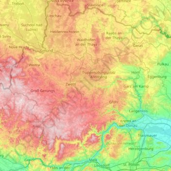
Name: Waldviertel topographic map, elevation, terrain.
Location: Waldviertel, Lower Austria, Austria (48.17114 14.69022 49.02052 15.95989)
Average elevation: 1,703 ft
Minimum elevation: 574 ft
Maximum elevation: 3,458 ft
Thank you for supporting this site ❤️
Make a donation
Make a donation
Gear up for your next adventure:
As an Amazon Associate, this site earns from qualifying purchases at no extra cost to you.
Other topographic maps
Click on a map to view its topography, its elevation and its terrain.
Lahnberg
Austria > Lower Austria > Bezirk Neunkirchen > Schwarzau im Gebirge
Average elevation: 3,980 ft