
Dunwich topographic map
Click on the map to display elevation.
About this map
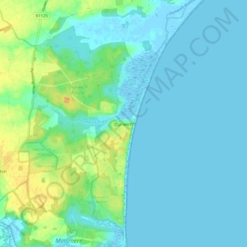
Name: Dunwich topographic map, elevation, terrain.
Location: Dunwich, East Suffolk, Suffolk, England, United Kingdom (52.24572 1.61097 52.30857 1.66080)
Average elevation: 23 ft
Minimum elevation: -13 ft
Maximum elevation: 102 ft
Other topographic maps
Click on a map to view its topography, its elevation and its terrain.
Falkenham Marshes
United Kingdom > England > Suffolk > East Suffolk > Falkenham
Average elevation: 0 ft
Felixstowe Marshes
United Kingdom > England > Suffolk > East Suffolk > Felixstowe
Average elevation: 3 ft