
Thank you for supporting this site ❤️
Make a donation
Make a donation
Gear up for your next adventure:
As an Amazon Associate, this site earns from qualifying purchases at no extra cost to you.
Caluma topographic map
Click on the map to display elevation.
Thank you for supporting this site ❤️
Make a donation
Make a donation
Gear up for your next adventure:
As an Amazon Associate, this site earns from qualifying purchases at no extra cost to you.
About this map
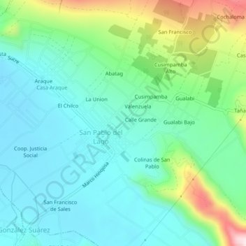
Name: Caluma topographic map, elevation, terrain.
Location: Caluma, San Pablo del Lago, Otavalo, Imbabura, 100210, Ecuador (0.17889 -78.20688 0.21889 -78.16688)
Average elevation: 9,091 ft
Minimum elevation: 8,730 ft
Maximum elevation: 10,148 ft
Thank you for supporting this site ❤️
Make a donation
Make a donation
Gear up for your next adventure:
As an Amazon Associate, this site earns from qualifying purchases at no extra cost to you.