
Make a donation
Gear up for your next adventure:
As an Amazon Associate, this site earns from qualifying purchases at no extra cost to you.
Tiltil topographic map
Click on the map to display elevation.
Make a donation
Gear up for your next adventure:
As an Amazon Associate, this site earns from qualifying purchases at no extra cost to you.
About this map
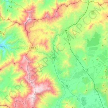
Name: Tiltil topographic map, elevation, terrain.
Average elevation: 3,087 ft
Minimum elevation: 840 ft
Maximum elevation: 7,274 ft
Make a donation
Gear up for your next adventure:
As an Amazon Associate, this site earns from qualifying purchases at no extra cost to you.
Other topographic maps
Click on a map to view its topography, its elevation and its terrain.
Las Casas de Chacabuco
Chile > Santiago Metropolitan Region > Provincia de Chacabuco > Colina > Chacabuco
Average elevation: 2,477 ft
Parque Industrial Los Libertadores
Chile > Santiago Metropolitan Region > Provincia de Chacabuco > Colina
Average elevation: 1,706 ft
Peldehue
Chile > Santiago Metropolitan Region > Provincia de Chacabuco > Colina
Average elevation: 2,438 ft
Valle de Luna
Chile > Santiago Metropolitan Region > Provincia de Chacabuco > Lampa
Average elevation: 1,998 ft
Make a donation
Gear up for your next adventure:
As an Amazon Associate, this site earns from qualifying purchases at no extra cost to you.
Coquimbo
Chile > Santiago Metropolitan Region > Provincia de Chacabuco > Batuco > Coquimbo
Average elevation: 1,637 ft
Chicureo
Chile > Santiago Metropolitan Region > Provincia de Chacabuco > Colina
Average elevation: 2,333 ft