
Make a donation
Gear up for your next adventure:
As an Amazon Associate, this site earns from qualifying purchases at no extra cost to you.
Tashkorgan Town topographic map
Click on the map to display elevation.
Make a donation
Gear up for your next adventure:
As an Amazon Associate, this site earns from qualifying purchases at no extra cost to you.
Tashkorgan Town
Aurel Stein argued that, judging from the topography and remains found around Tashkurgan, the fort and associated settlements had clearly been central to the broader Sarikol area, controlling routes from the Oxus to the oases of southern Turkestan.[13]
Make a donation
Gear up for your next adventure:
As an Amazon Associate, this site earns from qualifying purchases at no extra cost to you.
About this map
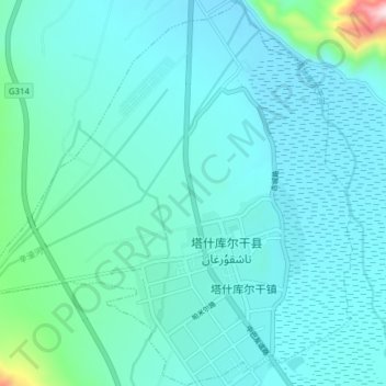
Name: Tashkorgan Town topographic map, elevation, terrain.
Average elevation: 10,200 ft
Minimum elevation: 9,993 ft
Maximum elevation: 12,178 ft
Make a donation
Gear up for your next adventure:
As an Amazon Associate, this site earns from qualifying purchases at no extra cost to you.