Geolocate

Long Neck topographic map

Click on the map to display elevation.

About this map

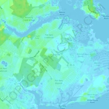
Name: Long Neck topographic map, elevation, terrain.

Location: Long Neck, Sussex County, Delaware, United States (38.60943 -75.17097 38.64943 -75.13097)

Average elevation: 10 ft

Minimum elevation: -23 ft

Maximum elevation: 49 ft

Sussex County trails, hiking, mountain biking, running and outdoor activities

Other topographic maps

Click on a map to view its topography, its elevation and its terrain.

Dagsboro

United States > Delaware > Sussex County

Average elevation: 30 ft

Fenwick Island

United States > Delaware > Sussex County

Average elevation: 0 ft

Henlopen Acres

United States > Delaware > Sussex County

Average elevation: 23 ft

Bethel

United States > Delaware > Sussex County

Average elevation: 26 ft

Blades

United States > Delaware > Sussex County

Average elevation: 23 ft

Bridgeville

United States > Delaware > Sussex County

Average elevation: 43 ft

Millville

United States > Delaware > Sussex County

Average elevation: 16 ft

Frankford

United States > Delaware > Sussex County

Average elevation: 33 ft

Dewey Beach

United States > Delaware > Sussex County

Average elevation: 7 ft

Laurel

United States > Delaware > Sussex County

Average elevation: 36 ft

Gear up for your next adventure:

📶Vehicle Signal Boosters - Improve reception in rural areas while driving to trailheads
🎁Geography Themed Gifts - Unique gift ideas for map lovers and geography enthusiasts
🖼️Topo Map Wall Art - Decorative topographic prints of famous peaks and regions
Solar GPS Watches - Advanced multisport watches with built-in topographic maps
🛠️Backpacking Tool Kit - Essential toolkit for outdoor repairs

As an Amazon Associate, this site earns from qualifying purchases at no extra cost to you.