
Make a donation
Gear up for your next adventure:
As an Amazon Associate, this site earns from qualifying purchases at no extra cost to you.
Bassignac topographic map
Click on the map to display elevation.
Make a donation
Gear up for your next adventure:
As an Amazon Associate, this site earns from qualifying purchases at no extra cost to you.
About this map
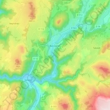
Name: Bassignac topographic map, elevation, terrain.
Average elevation: 1,765 ft
Minimum elevation: 1,181 ft
Maximum elevation: 2,674 ft
Make a donation
Gear up for your next adventure:
As an Amazon Associate, this site earns from qualifying purchases at no extra cost to you.
Other topographic maps
Click on a map to view its topography, its elevation and its terrain.
Lac de serre
France > Auvergne-Rhône-Alpes > Cantal > Saint-Saturnin > Le Fayet
Average elevation: 3,766 ft
Make a donation
Gear up for your next adventure:
As an Amazon Associate, this site earns from qualifying purchases at no extra cost to you.
Champs-sur-Tarentaine
France > Auvergne-Rhône-Alpes > Cantal > Champs-sur-Tarentaine-Marchal
Average elevation: 1,926 ft
Make a donation
Gear up for your next adventure:
As an Amazon Associate, this site earns from qualifying purchases at no extra cost to you.
Le Chassan
France > Auvergne-Rhône-Alpes > Cantal > Val d'Arcomie > Faverolles
Average elevation: 2,894 ft
Make a donation
Gear up for your next adventure:
As an Amazon Associate, this site earns from qualifying purchases at no extra cost to you.