Geolocate

Orašac topographic map

Click on the map to display elevation.

About this map

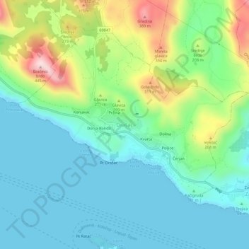
Name: Orašac topographic map, elevation, terrain.

Location: Orašac, Dubrovnik, Dubrovnik-Neretva County, 20234, Croatia (42.68107 17.99066 42.72107 18.03066)

Average elevation: 377 ft

Minimum elevation: -3 ft

Maximum elevation: 1,407 ft

Other topographic maps

Click on a map to view its topography, its elevation and its terrain.

Dubrovnik

Croatia > Dubrovnik-Neretva County > Dubrovnik

Average elevation: 213 ft

Gear up for your next adventure:

🛰️Satellite Messengers - Emergency SOS and two-way messaging for off-grid adventures
🏥Hiking First Aid Kits - Comprehensive medical kits for remote trail injuries
🧭Hiking Compass - Precision compass for reliable navigation in the wilderness
🕶️GPS Smartphone Mount - Secure mount for phone navigation
🧭Outdoor Navigation Book - Learn advanced navigation skills

As an Amazon Associate, this site earns from qualifying purchases at no extra cost to you.