
Thank you for supporting this site ❤️
Make a donation
Make a donation
Gear up for your next adventure:
As an Amazon Associate, this site earns from qualifying purchases at no extra cost to you.
Gyesan-dong topographic map
Click on the map to display elevation.
Thank you for supporting this site ❤️
Make a donation
Make a donation
Gear up for your next adventure:
As an Amazon Associate, this site earns from qualifying purchases at no extra cost to you.
About this map
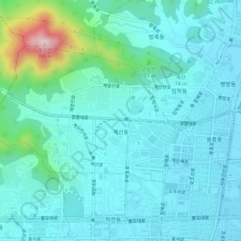
Name: Gyesan-dong topographic map, elevation, terrain.
Location: Gyesan-dong, Gyeyang-gu, Incheon, South Korea (37.53351 126.70492 37.55284 126.74430)
Average elevation: 217 ft
Minimum elevation: 23 ft
Maximum elevation: 1,240 ft
Thank you for supporting this site ❤️
Make a donation
Make a donation
Gear up for your next adventure:
As an Amazon Associate, this site earns from qualifying purchases at no extra cost to you.