
Thank you for supporting this site ❤️
Make a donation
Make a donation
Gear up for your next adventure:
As an Amazon Associate, this site earns from qualifying purchases at no extra cost to you.
Monte Barro topographic map
Click on the map to display elevation.
Thank you for supporting this site ❤️
Make a donation
Make a donation
Gear up for your next adventure:
As an Amazon Associate, this site earns from qualifying purchases at no extra cost to you.
Monte Barro
De Monte Barro is een berg nabij Lecco in Lombardije, Italië, met een hoogte van 922 meter.
Thank you for supporting this site ❤️
Make a donation
Make a donation
Gear up for your next adventure:
As an Amazon Associate, this site earns from qualifying purchases at no extra cost to you.
About this map
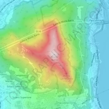
Name: Monte Barro topographic map, elevation, terrain.
Location: Monte Barro, Galbiate, Lecco, Lombardije, 23851, Italië (45.83074 9.38016 45.83084 9.38026)
Average elevation: 1,348 ft
Minimum elevation: 646 ft
Maximum elevation: 2,894 ft
Thank you for supporting this site ❤️
Make a donation
Make a donation
Gear up for your next adventure:
As an Amazon Associate, this site earns from qualifying purchases at no extra cost to you.