Geolocate

Morente topographic map

Click on the map to display elevation.

About this map

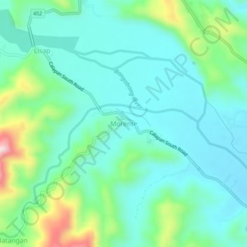
Name: Morente topographic map, elevation, terrain.

Location: Morente, Oriental Mindoro, Mimaropa, 5211, Philippines (12.65933 121.36077 12.69933 121.40077)

Average elevation: 548 ft

Minimum elevation: 282 ft

Maximum elevation: 1,411 ft

Other topographic maps

Click on a map to view its topography, its elevation and its terrain.

Bongabong River

Philippines > Oriental Mindoro

Average elevation: 1,972 ft

Inclanay Dam

Philippines > Oriental Mindoro > Inclanay > Pansulan

Average elevation: 95 ft

Bansud River

Philippines > Oriental Mindoro > Conrazon

Average elevation: 1,132 ft

Naujan Lake

Philippines > Oriental Mindoro > Malabo

Average elevation: 151 ft

Masipit

Philippines > Oriental Mindoro > Calapan

Average elevation: 13 ft

Tawiran

Philippines > Oriental Mindoro > Calapan

Average elevation: 20 ft

Lalud

Philippines > Oriental Mindoro > Calapan > Guinobatan

Average elevation: 26 ft

Gear up for your next adventure:

🔥Camping Stove - Portable stove for camping and backcountry cooking
🎒Trail Energy Bars - High‑calorie bars for hiking energy
⛑️Personal Locator Beacon - Safety beacon for emergencies
🏕️Family Camping Gear - Essentials for group camping trips
🌐World Map Poster - Decorative world maps with topographic info

As an Amazon Associate, this site earns from qualifying purchases at no extra cost to you.