Geolocate

Masipit topographic map

Click on the map to display elevation.

👉 Easily get elevation data in JSON, GeoTIFF and KML formats using Elevation API
Thank you for supporting this site ❤️
Make a donation

About this map

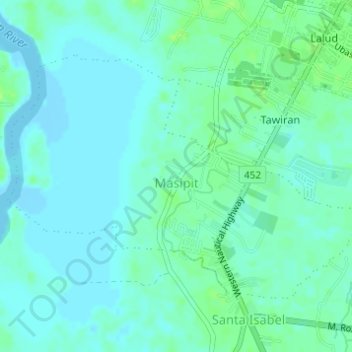
Name: Masipit topographic map, elevation, terrain.

Location: Masipit, Calapan, Oriental Mindoro, Mimaropa, Philippines (13.37880 121.14364 13.39945 121.17425)

Average elevation: 13 ft

Minimum elevation: -3 ft

Maximum elevation: 36 ft

Other topographic maps

Click on a map to view its topography, its elevation and its terrain.

Aganhaw

Philippines > Oriental Mindoro > Calapan > Parang

Average elevation: 79 ft

Guinobatan

Philippines > Oriental Mindoro > Calapan

Average elevation: 82 ft

Silonay

Philippines > Oriental Mindoro > Calapan

Average elevation: 46 ft

Parang

Philippines > Oriental Mindoro > Calapan

Average elevation: 82 ft

Nazareto

Philippines > Oriental Mindoro > Calapan > Lazareto

Average elevation: 23 ft

Bonbon

Philippines > Oriental Mindoro > Calapan > Lazareto

Average elevation: 46 ft

Balete

Philippines > Oriental Mindoro > Calapan > Balete

Average elevation: 7 ft

Magindat

Philippines > Oriental Mindoro > Calapan

Average elevation: 33 ft

Canubing

Philippines > Oriental Mindoro > Calapan

Average elevation: 23 ft

Gear up for your next adventure:

🥾Hiking Shoes - Durable and comfortable shoes for trail hiking
🧥Men's Rain Shells - Premium waterproof and breathable jackets for mountain weather
🎒Hydration Pack - Hands‑free water reservoir for long hikes
Backpacking Tent - Lightweight and durable tent for multi‑day hikes
🛌Ultralight Sleeping Bags - Compact down bags for cold nights in the wilderness

As an Amazon Associate, this site earns from qualifying purchases at no extra cost to you.