Geolocate

Siralkoppa topographic map

Click on the map to display elevation.

Siralkoppa

Shiralakoppa is located at 14°23′N 75°15′E / 14.38°N 75.25°E / 14.38; 75.25. It has an average elevation of 595 metres (1952 feet). Shiralakoppa is 70 km away from Shimoga and 20 km from Shikaripura.

Wikipedia (CC-BY-SA 3.0)

About this map

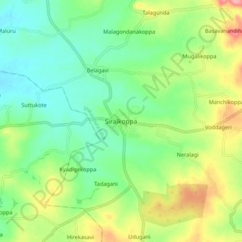
Name: Siralkoppa topographic map, elevation, terrain.

Location: Siralkoppa, Shikaripura taluk, Shimoga, Karnataka, 577428, India (14.34192 75.20879 14.42192 75.28879)

Average elevation: 2,037 ft

Minimum elevation: 1,913 ft

Maximum elevation: 2,257 ft

Other topographic maps

Click on a map to view its topography, its elevation and its terrain.

Shikaripura taluk

India > Karnataka > Shikaripura taluk

Average elevation: 2,077 ft

Gear up for your next adventure:

📶Satellite Messenger - Communication device off‑grid
🩹Survival Bandages - High‑quality bandages for emergencies
🛡️Bear Spray Outdoor - Protection in bear country hikes
💧Water Purification System - Clean water on the trail with reliable purifiers
GPS Sports Watch - GPS watch for running, hiking and training

As an Amazon Associate, this site earns from qualifying purchases at no extra cost to you.