
Thank you for supporting this site ❤️
Make a donation
Make a donation
Gear up for your next adventure:
As an Amazon Associate, this site earns from qualifying purchases at no extra cost to you.
Senari topographic map
Click on the map to display elevation.
Thank you for supporting this site ❤️
Make a donation
Make a donation
Gear up for your next adventure:
As an Amazon Associate, this site earns from qualifying purchases at no extra cost to you.
About this map
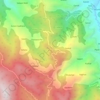
Name: Senari topographic map, elevation, terrain.
Location: Senari, Dhalikhet, Ranikhet, Almora, Uttarakhand, India (29.63453 79.32451 29.67453 79.36451)
Average elevation: 4,797 ft
Minimum elevation: 3,100 ft
Maximum elevation: 6,490 ft
Thank you for supporting this site ❤️
Make a donation
Make a donation
Gear up for your next adventure:
As an Amazon Associate, this site earns from qualifying purchases at no extra cost to you.