
Make a donation
Gear up for your next adventure:
As an Amazon Associate, this site earns from qualifying purchases at no extra cost to you.
Hohe Tauern topographic map
Click on the map to display elevation.
Make a donation
Gear up for your next adventure:
As an Amazon Associate, this site earns from qualifying purchases at no extra cost to you.
Hohe Tauern
The best-known mountain pass road of the High Tauern is the scenic Grossglockner High Alpine Road inaugurated in 1935, including a tunnel at an elevation of 2,505 metres (8,219 ft) under the Hochtor Pass (2,573 metres (8,442 ft)). East of it, the Katschberg Pass (1,641 metres (5,384 ft)) on B 99 Katschberg Straße highway parallel to the Katschberg Tunnel links Sankt Michael and Rennweg. Another road crosses the Staller Sattel between Sankt Jakob in Defereggen and Rasen-Antholz at 2,052 metres (6,732 ft).
Make a donation
Gear up for your next adventure:
As an Amazon Associate, this site earns from qualifying purchases at no extra cost to you.
About this map
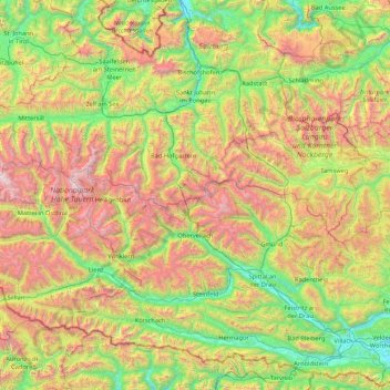
Name: Hohe Tauern topographic map, elevation, terrain.
Location: Hohe Tauern, Salzburg, Austria (46.78095 11.91980 47.32363 13.62356)
Average elevation: 4,895 ft
Minimum elevation: 1,516 ft
Maximum elevation: 12,047 ft
Make a donation
Gear up for your next adventure:
As an Amazon Associate, this site earns from qualifying purchases at no extra cost to you.