
Lead topographic map
Click on the map to display elevation.
Lead
Its high elevation in the Black Hills makes Lead one of the wettest places in South Dakota and among the snowiest places in the contiguous United States with a mean snowfall of 183.9 inches or 4.67 metres. During the cold and snowy winter of 1993–94, a whopping 364.7 inches (9.26 m) of snow fell and three years later snowfall totalled 324.0 inches (8.23 m). However, frequent chinook winds mean that most of the enormous snowfall melts during the winter: the highest snow cover on record is 73 inches (1.85 m) on March 1, 1998 – during a storm that totalled 114.6 inches or 2.91 metres of snow (water equivalent 4.12 inches or 104.6 millimetres) over six days ending March 2. Mean snow depth in January is only 7 inches or 0.18 metres and the median even less at 5 inches or 0.13 metres. 12.9 mornings can be expected to fall to or below 0 °F (−17.8 °C), with the average window for zero temperatures being December 7 to March 3; on the other hand during winter 12.8 afternoons can be expected to get to or above 50 °F or 10 °C. The coldest temperature has been −40 °F or −40 °C on February 8, 1936.
About this map
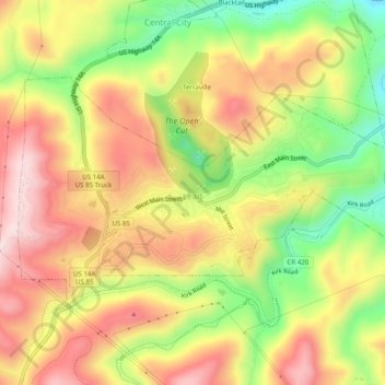
Name: Lead topographic map, elevation, terrain.
Location: Lead, Lawrence County, South Dakota, United States (44.34184 -103.79077 44.36266 -103.73826)
Average elevation: 5,266 ft
Minimum elevation: 4,642 ft
Maximum elevation: 5,827 ft
Lawrence County trails, hiking, mountain biking, running and outdoor activities
Other topographic maps
Click on a map to view its topography, its elevation and its terrain.