
Make a donation
Gear up for your next adventure:
As an Amazon Associate, this site earns from qualifying purchases at no extra cost to you.
Baldringen topographic map
Click on the map to display elevation.
Make a donation
Gear up for your next adventure:
As an Amazon Associate, this site earns from qualifying purchases at no extra cost to you.
Baldringen
Baldringen liegt im Naturpark Saar-Hunsrück etwa neun Kilometer westlich von Kell am See unweit des Treffpunktes der Bundesstraßen 268 (Trier–Saarbrücken) und 407 (Hunsrückhöhenstraße) bei Zerf.
Make a donation
Gear up for your next adventure:
As an Amazon Associate, this site earns from qualifying purchases at no extra cost to you.
About this map
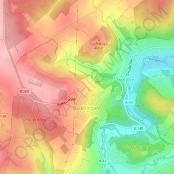
Name: Baldringen topographic map, elevation, terrain.
Average elevation: 1,394 ft
Minimum elevation: 1,063 ft
Maximum elevation: 1,650 ft
Make a donation
Gear up for your next adventure:
As an Amazon Associate, this site earns from qualifying purchases at no extra cost to you.
Other topographic maps
Click on a map to view its topography, its elevation and its terrain.